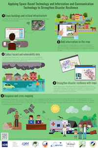
This project aims to improve local data collection by introducing mobile applications and a webviewing platform to governments and communities. These tools allow decision makers to improve response, recovery and reconstruction efforts. At the national level SBT applications are introduced for governments to make national plans and quickly assess the damages in case of natural disaster

Activities

Step 1.

Use OSM to put buildings and critical infrastructure on the map.

Step 2.

Add information to buildings and critical infrastructure using geoMapTool and sync this information to OSM for everyone to see.

Step 3.

Record and take pictures of hazards and vulnerabilities in your community using geoBingAn.

Step 4.

Make community based hazard and evacuation map in geoBingAn web using reports from step 3.

Step 5.

During a disaster combine emergency observation imagery from Sentinel Asia and International Disaster Charter with crisis mapping data collected in the field using geoBingAn.

Download the poster here

System Overview

Mapping Tools

Generic placeholder thumbnail

geoMapTool

Learn more

Generic placeholder thumbnail

geoBingAn App

Learn more

Generic placeholder thumbnail

geoBingAn Web

Learn more

All the mapping tools have been developed by

Case Studies in Four Countries

Select the blue pin to find the results of each case study

e-learning

Take our self directed e-learning course to run this project in your community.